Fair Areas: Difference between revisions
Public wiki for the 1904 Louisiana Purchase Exposition
No edit summary |
No edit summary |
||
| (7 intermediate revisions by the same user not shown) | |||
| Line 1: | Line 1: | ||
__NOTOC__ | __NOTOC__ | ||
{{#tag:imagemap| | {{#tag:imagemap| | ||
Image: | Image:Fair Areas.jpg {{!}}{{{1|100%}}} | ||
poly 165 629 331 628 164 529 71 362 47 386 46 450 112 560 [[Model City|Model City]] | poly 165 629 331 628 164 529 71 362 47 386 46 450 112 560 [[Model City|Model City]] | ||
poly | poly 172 638 173 693 501 696 502 723 631 725 630 634[[The Pike|The Pike]] | ||
poly 586 616 592 489 533 490 486 465 427 463 420 452 422 404 382 354 306 341 253 371 207 288 71 361 165 527 334 621 [[Main Picture|Main Picture]] | poly 586 616 592 489 533 490 486 465 427 463 420 452 422 404 382 354 306 341 253 371 207 288 71 361 165 527 334 621 [[Main Picture|Main Picture]] | ||
poly 85 73 97 62 120 63 130 57 133 36 245 37 245 119 246 149 220 200 220 215 191 246 208 288 71 359 46 386 57 293 [[Plateau of States|Plateau of States]] | poly 85 73 97 62 120 63 130 57 133 36 245 37 245 119 246 149 220 200 220 215 191 246 208 288 71 359 46 386 57 293 [[Plateau of States|Plateau of States]] | ||
| Line 9: | Line 9: | ||
poly 345 222 362 256 432 273 468 292 416 386 385 351 344 333 306 340 254 370 210 286 268 255 [[Art Hill|Art Hill]] | poly 345 222 362 256 432 273 468 292 416 386 385 351 344 333 306 340 254 370 210 286 268 255 [[Art Hill|Art Hill]] | ||
poly 629 623 631 502 644 180 603 182 611 230 605 252 583 275 566 285 526 275 522 298 469 290 416 386 421 453 429 464 487 465 536 490 593 490 587 615 610 615 [[The Trail|The Trail]] | poly 629 623 631 502 644 180 603 182 611 230 605 252 583 275 566 285 526 275 522 298 469 290 416 386 421 453 429 464 487 465 536 490 593 490 587 615 610 615 [[The Trail|The Trail]] | ||
poly 652 177 652 115 661 35 738 59 750 80 773 154 768 182 [[Livestock | poly 652 177 652 115 661 35 738 59 750 80 773 154 768 182 [[Livestock|Livestock]] | ||
poly 657 350 654 179 767 183 773 153 790 227 793 260 788 303 774 336 775 359 788 416 798 429 859 409 867 411 867 427 903 446 902 479 851 513 866 550 723 553 753 485 752 469 708 469 707 498 638 498 658 379 [[Agriculture Area|Agriculture Area]] | poly 657 350 654 179 767 183 773 153 790 227 793 260 788 303 774 336 775 359 788 416 798 429 859 409 867 411 867 427 903 446 902 479 851 513 866 550 723 553 753 485 752 469 708 469 707 498 638 498 658 379 [[Agriculture Area|Agriculture Area]] | ||
poly 864 109 783 143 774 154 791 229 796 264 791 304 775 337 778 359 791 417 801 429 918 395 942 401 943 248 961 206 957 195 903 172 881 152 872 139 872 139 [[Philippine Exhibit|Philippine Exhibit]] | poly 864 109 783 143 774 154 791 229 796 264 791 304 775 337 778 359 791 417 801 429 918 395 942 401 943 248 961 206 957 195 903 172 881 152 872 139 872 139 [[Philippine Exhibit|Philippine Exhibit]] | ||
poly 914 549 914 514 924 493 919 403 914 397 868 411 867 429 904 445 901 480 852 514 867 551 [[ | poly 914 549 914 514 924 493 919 403 914 397 868 411 867 429 904 445 901 480 852 514 867 551 [[Anthropology Area|Anthropology Area]] | ||
poly 637 500 639 698 728 700 725 493 751 480 750 469 708 469 708 486 715 499 [[Place of Nations|Place of Nations]] | poly 637 500 639 698 728 700 725 493 751 480 750 469 708 469 708 486 715 499 [[Place of Nations|Place of Nations]] | ||
poly 726 689 726 560 1086 553 1083 669 1023 663 1024 699 761 698 761 698 [[Washington University|Washington University]] | poly 726 689 726 560 1086 553 1083 669 1023 663 1024 699 761 698 761 698 [[Washington University|Washington University]] | ||
| Line 37: | Line 37: | ||
*[[Livestock]]-Place where farm animals were | *[[Livestock]]-Place where farm animals were | ||
[[Category:Areas]] | [[Category:Areas]] | ||
Latest revision as of 05:39, 26 February 2024
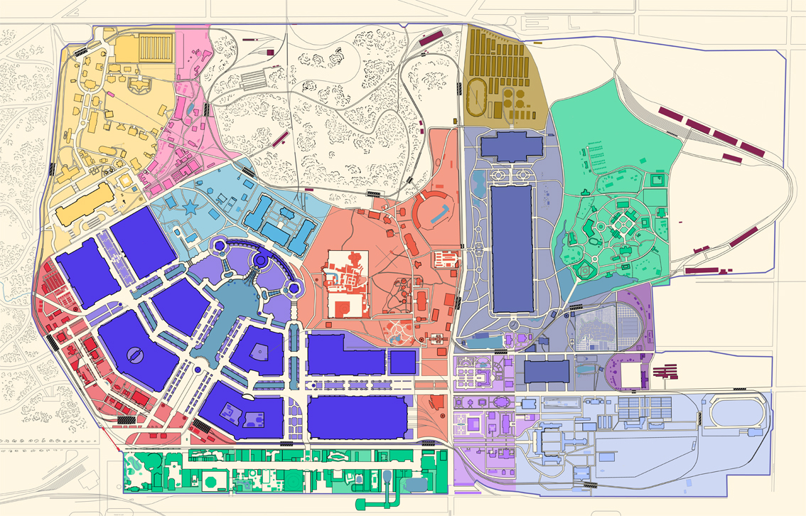
- Main Picture - The central portion of the fair, hosting the Palaces
- The Pike - A mile-long amusement lane, similar to a midway.
- Plateau of States - An elevated plateau, where many of the State buildings were built.
- Art Hill - Area including the Art Museum and attractions nearby.
- Place of Nations - Many international buildings were located here.
- Anthropology Area - Tribes of Native Americans were displayed in this area.
- Philippine Exhibit - The newly acquired Philippines were showcased here.
- Agriculture Area - Many outdoor exhibits based on farm life were hosted here.
- The Trail - A forested area with many attractions, and some state buildings.
- Mining Gulch - A natural valley filled with outdoor mining exhibits.
- Washington University - Contained many administration buildings, and attractions.
- Model City - A demonstration of urban planning.
- Support Buildings - The fair required many support structures to ensure operation.
- Livestock-Place where farm animals were