Maps: Difference between revisions
No edit summary |
No edit summary |
||
| (5 intermediate revisions by the same user not shown) | |||
| Line 1: | Line 1: | ||
{{SHORTDESC:Maps}} | {{SHORTDESC:Maps}} | ||
__NOTOC__ | |||
[[Cartography:Maps]] | |||
[[Cartography:1901Park]] | |||
[[Cartography:1902GroundPlan]] | |||
[[Cartography:Jul1902GroundPlan]] | |||
[[Cartography:Sep1902GroundPlan]] | |||
[[Cartography:Oct1902GroundPlan]] | |||
[[Cartography:Oct1903GroundPlan]] | |||
[[Cartography:CivilEngineering]] | |||
[[Cartography:SherlocksGuide]] | |||
[[Cartography:1904ThePike]] | |||
[[Cartography:AcornMap]] | |||
[[Cartography:1904GroundPlan]] | |||
[[Cartography:GroundPlan]] | |||
[[Cartography:Mar1904GroundPlan]] | |||
[[Cartography:Oct1904GroundPlan]] | |||
[[Cartography:LyleManingerMap]] | |||
Maps of the Fair | Maps of the Fair | ||
Below is a collection of high resolution maps of the fair through the years. | |||
==1901== | ==1901== | ||
<gallery | class="center" | mode=packed-hover | widths=350px heights=150px>> | <gallery | class="center" | mode=packed-hover | widths=350px heights=150px>> | ||
File:1901 - Forest Park.jpg|Map of Forest Park in 1901 | File:1901 - Forest Park.jpg|Map of Forest Park in 1901 | ||
| Line 25: | Line 43: | ||
<gallery | class="center" | mode=packed-hover | widths=350px heights=150px>> | <gallery | class="center" | mode=packed-hover | widths=350px heights=150px>> | ||
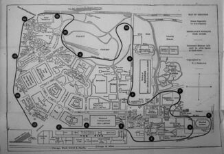
File:1904 - Civil Engineering Map.jpg | Map showing Civic features of the Fair | File:1904 - Civil Engineering Map.jpg | Map showing Civic features of the Fair | ||
File:1904 - Sherlocks Worlds Fair Guide.jpg | File:1904 - Sherlocks Worlds Fair Guide.jpg | Map focused on Intramural Stops for the Sherlock Guide | ||
File:1904 - The Pike.jpg | File:1904 - The Pike.jpg | A map of the Pike from early 1904 | ||
File:1904 Acorn Map.jpg | File:1904 Acorn Map.jpg | The map of the fair often included with the Fair in a Nutshell. | ||
File:Ground Plan 1904.jpg | File:Ground Plan 1904.jpg | ||
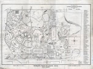
File:Ground Plan.jpg | File:Ground Plan.jpg | The most popular map of the fair, popularized by the Missouri History Museum | ||
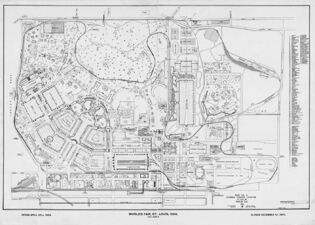
File:March 1904 Ground Plan.jpg | File:March 1904 Ground Plan.jpg | ||
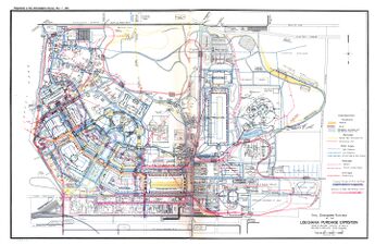
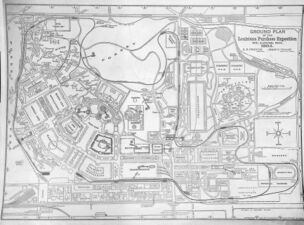
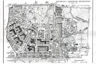
File:October 1904 Ground Plan.jpg | File:October 1904 Ground Plan.jpg | The Mercantile Map, drawn after the fair from Fair records | ||
</gallery> | </gallery> | ||
Latest revision as of 23:01, 17 March 2024
Cartography:Maps Cartography:1901Park Cartography:1902GroundPlan Cartography:Jul1902GroundPlan Cartography:Sep1902GroundPlan Cartography:Oct1902GroundPlan Cartography:Oct1903GroundPlan Cartography:CivilEngineering Cartography:SherlocksGuide Cartography:1904ThePike Cartography:AcornMap Cartography:1904GroundPlan Cartography:GroundPlan Cartography:Mar1904GroundPlan Cartography:Oct1904GroundPlan Cartography:LyleManingerMap
Maps of the Fair Below is a collection of high resolution maps of the fair through the years.
1901[edit | edit source]
-
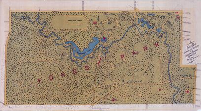
Map of Forest Park in 1901

1902[edit | edit source]
-
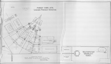
Early plan of fair showing the basic 'Fan' Design
-
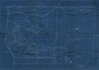
Blueprint of the fair, showing rough building placements
-
Revised ground plan of September 1902
-
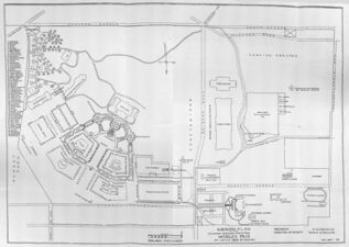
Final Ground Plan of 1902


1903[edit | edit source]

1904[edit | edit source]
-
Map showing Civic features of the Fair
-
Map focused on Intramural Stops for the Sherlock Guide
-
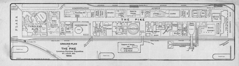
A map of the Pike from early 1904
-
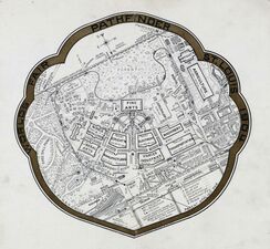
The map of the fair often included with the Fair in a Nutshell.
-
-
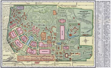
The most popular map of the fair, popularized by the Missouri History Museum
-
-
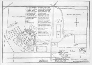
The Mercantile Map, drawn after the fair from Fair records


1972[edit | edit source]
-
Map drawn in 1972 from the Mercantile Map, with 3D elements added

2023[edit | edit source]
-
A modern view of the fair
-
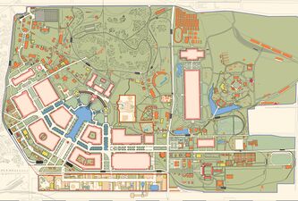
A map illustrated in a vintage fashion
-
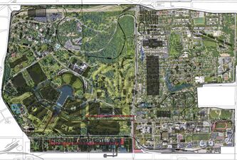
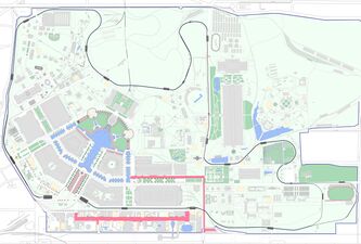
Overlay of Roads and Buildings onto Satellite Map
-
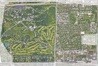
Google Satellite Map of Forest Park in 2023


